Wildfires have become a real disaster for Southern Europe in recent years, causing suffering not only to animal and plant species but also to insurers’ budgets. Costing well over €1 billion every single year, companies are searching for a solution to prevent, or at least track, these rapidly moving cataclysms on Earth and above.
Supported by ESA’s InCubed program, innovators like EOSDA deliver real-time fire detection and automate claims. The insurance sector is one of those sectors ready to adopt space tech, in Portugal as well. And actually, the orbit and real-time satellite images offer insurers much crucial information, minimizing the guesswork and accurately evaluating risks.
The Burning Problem for Insurers: A €21 Billion Wake-Up Call
During the 2024-2025 season, the Southern European region burned through 119% of its historical average. Portugal alone saw 143,400 hectares go up in smoke, bringing the total across the Iberian Peninsula to nearly 700,000 hectares destroyed. France, Greece, and Italy weren’t spared either, facing fire seasons well above the norm.
The economic fallout? A staggering €21 billion in annual losses across the continent. If current trends hold, analysts warn that the number could explode to an unmanageable €50 billion by 2030.
To survive this, insurers need undeniable facts. Pricing risk based on outdated maps or yesterday’s data is practically financial suicide today. Instead, smart planning now heavily relies on current satellite imagery. By analyzing shifting vegetation and local vulnerabilities from orbit, insurers can accurately assess the danger before a single spark is struck.
The Reality of Claims: Portugal’s Severe Protection Gap
You can clearly see this financial strain in Portugal. The September wildfires alone sparked €17 million in claims, according to the Portuguese Association of Insurers (APS). The breakdown of these payouts reveals a massive hit across the board:
- 67% impacted business multi-risk policies.
- 25% fell directly on residential housing.
- €800,000 went toward personal accident and work policies covering tragic bodily injuries and deaths.
But these big numbers hide a much scarier reality: the region’s massive protection gap. Right now, only 53% of homes in Portugal actually have dedicated fire insurance. That leaves nearly half of all households (47%) crossing their fingers, effectively self-insuring, or hoping for underfunded state aid if disaster strikes.
So, how can insurers step in and cover these unprotected homes without taking on impossible, toxic risks? They have to keep a constant eye on the changing environment. By pulling up a live satellite view, risk assessors can pinpoint exactly how close a house sits to a high-risk forest zone.
Scorched Earth: The Devastating Agricultural Toll in Spain
The devastation extends far beyond city limits and suburban neighborhoods. Across the Iberian Peninsula, the agricultural sector is taking an absolute beating that simply isn’t sustainable.
In Spain alone, the rural economy is facing catastrophic losses:
- Over $700 million in damages to timber, livestock, and crops, according to a major farmers’ organization.
- 73 square miles of vital farmland entirely wiped out, as reported by Agroseguro, the Spanish agricultural insurance consortium.
- Unprecedented, disproportionate losses for specialized operations, particularly beekeepers and poultry farmers.
- A massive €4.5 billion wider economic hit across the peninsula when factoring in lost production and infrastructure, according to a European Commission study.
When dealing with destruction on this massive scale, sending human adjusters out to manually inspect hazardous, smoldering fields is agonizingly slow and resource-heavy. Farmers need payouts immediately, not next month. To speed up the claims process and safely verify the exact boundaries of ruined crops, adjusters are leaning heavily on current satellite views. This immediate overhead intelligence cuts through the red tape, eliminates human error, and prevents claim fraud.
Rewriting Wildfire Defense from Orbit
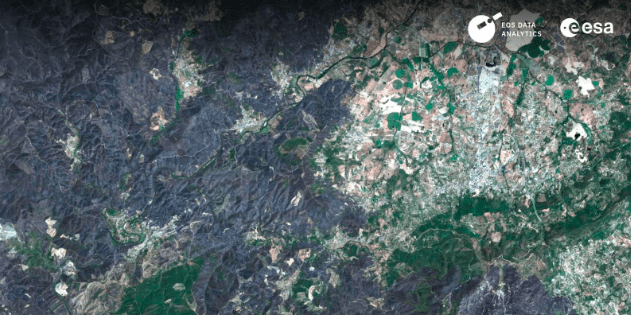
Last year, Coimbra Region in Portugal faced its worst wildfire season, losing 64,000 hectares. And in March 2026, the ESA InCubed program launched a 12-month partnership with EOS Data Analytics and local authorities to minimize the risk of this disaster in future.
This project completely ditches slow terrestrial sensors for undeniable, space-based intelligence. Armed with the high-definition EOS SAT-1 satellite, local risk managers are now monitoring 4,336 square kilometers across 19 municipalities. By utilizing the most current satellite imagery, assessors can spot dangerous vegetation vulnerabilities long before a single spark catches.
Raw data is finally being translated into immediate, actionable defense:
- Automated quarterly maps that track shifting forest density and pinpoint escalating fire risks.
- Highly precise burned-area mapping to speed up insurance claims and jumpstart local recovery.
- Direct data feeds straight into Coimbra’s SADGE emergency management platform.
So, how do insurers rapidly figure out localized destruction without sending adjusters into smoldering, dangerous zones? They simply don’t. By pulling up a live satellite view, underwriters completely bypass those costly, hazardous delays. This initiative in Coimbra is hard proof that space technology is finally dragging the European insurance market away from reactive guesswork and into proactive, data-driven defense.
Why Satellite Intelligence Is the Only Way Forward
The reactive insurance model is officially dead. To survive escalating climate risks, the industry must demand objective, immediate data. By utilizing current satellite images, underwriters gain the indisputable proof needed to combat fraud and automate claims instantly. Relying on the best live satellite view available is the only proven way to track fast-moving devastation and maintain profitability. The question isn’t whether insurers will adopt this intelligence, but how fast.