GPS Earth Live Satellite Maps, enhanced with the intelligent capabilities of AI & Earth Satellite Maps, represent the next generation of travel and navigation technology. These aren’t just digital directions—they’re immersive, interactive tools that bring the entire globe into your pocket. Whether you’re traveling across continents or exploring your local neighborhood, these live satellite maps provide a rich, detailed, and responsive navigation experience.
This advanced system combines GPS tracking, satellite imaging, and a smart AI chatbot to offer everything from 3D Earth maps to live traffic monitoring and tourist spot recommendations. It’s built for modern explorers—offering convenience, accuracy, and adventure in one smart interface.
What Makes GPS Earth Live Satellite Maps Stand Out?
Real-Time Global Navigation at Your Fingertips
- At the core of this technology is real-time AI Earth Satellite Maps enabling users to:
- View live satellite location map with pin-point accuracy
- Monitor traffic flows and congestion
- Track weather changes and terrain in real-time
- Navigate using multiple views—satellite, street, hybrid, and terrain
- With this, users stay informed, aware, and in control of their routes at all times.
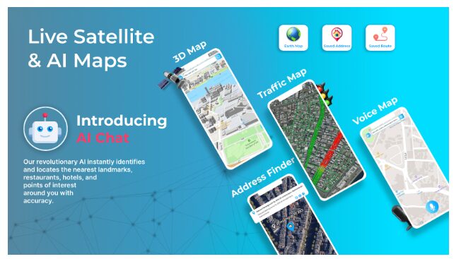
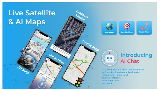
- Meet AI Maps – Your Personal Travel Chatbot
One of the most innovative features is AI Maps, a smart AI travel assistant built to answer all your travel queries. Whether you need help finding a hidden restaurant, planning an itinerary, or translating signs in a foreign city—AI Maps does it all.
AI Maps Key Features:
Ask natural language questions like “What’s the best route to the Eiffel Tower?”
Get real-time suggestions for tourist places, hotels, and restaurants
Virtually visit destinations before arriving
Receive safety tips, travel advice, and weather updates
This AI-powered chatbot is perfect for travelers, digital nomads, and everyday users looking for intelligent, context-aware guidance.
Advanced Mapping Features to Elevate Your Travel Experience
3D Maps and Height Map Visualization
The 3D Earth Maps feature lets you explore cities and terrains in rich detail. You can rotate, zoom, and view entire regions with realistic building structures. The addition of Height Map visualization takes it a step further:
Buildings are color-coded based on height
Easier understanding of urban layouts and architecture
Ideal for urban explorers, planners, and photographers
With 3D and height mapping, users get a visually immersive, interactive travel experience.
Distance Finder – Get Accurate Route Measurements
Need to know how far you are from your destination? The Distance Finder tool allows you to:
Measure the distance between two or more points
Save your routes for later use
Switch between walking, biking, or driving options
Plan hikes, tours, or delivery routes with real-time efficiency
Paired with AI Maps, it offers dynamic route suggestions based on distance, traffic, and preferences.
Voice Maps – Travel Hands-Free and Hassle-Free
For those on the go, Voice Maps is a game-changer. With this feature, you can:
Navigate using voice commands
Request travel recommendations
Get spoken updates on traffic and surroundings
Use AI Maps as a voice-activated travel guide
This hands-free functionality ensures safe, smart, and responsive travel whether you’re driving, walking, or cycling.
- Address Finder – Locate Any Place Instantly
- The Address Finder makes it simple to:
- Pinpoint hidden spots and unmarked locations
- Access real-time live location and directions
- View street-level previews for better orientation
This tool is ideal for delivery personnel, tourists, and real estate agents who need exact destination details. With Live Satellite Maps views, users can find any address instantly and confidently.
Traffic Map – Avoid Jams and Travel Smarter
The integrated Traffic Map uses real-time data to:
Show traffic congestion levels
Identify roadblocks, construction zones, or accidents
Offer alternate routes based on live conditions
Combined with AI Maps, you receive automatic rerouting suggestions and time-saving options—all in real-time.
Tourist Places – Explore Top Attractions with AI Guidance
Looking for the best places to visit in a new city? Let AI Maps be your personal digital tour guide. The bot can:
Recommend top-rated tourist attractions
Build personalized sightseeing itineraries
Share historical facts, local insights, and travel tips
Whether you’re in Paris, Tokyo, or a small village in the Alps, AI Maps ensures you make the most of every journey.
Satellite Map for Nature Exploration and Remote Locations
For nature lovers, GPS Earth Live Satellite Maps unlock access to:
- National parks
- Remote mountain trails
- Wildlife reserves
- Hidden natural wonders
You can scout locations, assess terrain conditions, and plan your route—all while AI Maps assists with relevant tips and safety info.
Smart Technology Behind the Scenes
AI-Powered Navigation and Personalization
AI Maps isn’t just smart—it’s adaptive. It learns your travel patterns, adjusts routes based on real-time factors, and remembers your preferences. Whether you’re a frequent flyer or a weekend hiker, the AI evolves with you.
Ground-Level Data + Satellite Imaging = Total Clarity
By merging satellite views with user-contributed and ground-level data, the system offers:
A complete environmental overview
- Real-time weather, traffic, and accessibility insights
- Better decision-making before and during travel
The Future of Smart Mapping is Already Here
- Emerging technologies will soon elevate the experience further with:
- AR (Augmented Reality) overlays for real-world navigation
- Offline AI guidance for remote areas
- Eco-routing to reduce emissions and fuel costs
- Crowdsourced updates for local intel and trail conditions
AI & Satellite Maps are built for the future of travel—sustainable, intuitive, and globally connected.
Conclusion
GPS Earth Live Satellite Maps, supercharged by the intelligent travel assistant AI Maps, deliver a next-gen navigation experience. From satellite-level accuracy to AI-powered recommendations, 3D terrain views to real-time traffic updates, this tool isn’t just a map—it’s your ultimate travel companion.
Read More From Techbullion