Modern excavation technology cuts construction timelines mainly by replacing slow manual surveying and constant rework with real-time digital data. GPS machine control, drone surveying, and connected telematics let a crew dig straight to a 3D design model, which can shave days or even weeks off the earthwork phase that traditionally holds up the rest of a build.
The shift is bigger than a few gadgets. When a grading plan exists as a digital surface instead of a stack of paper drawings, the equipment itself knows exactly where the design grade sits, and the operator stops second-guessing every pass. Practical breakdowns like the ones at siteprep.com show how that single change ripples through an entire schedule, from the first survey flight to the last compaction check.
What is smart excavation technology?
Smart excavation technology is the package of GNSS machine control, drone mapping, and equipment telematics that lets crews build to a digital 3D model instead of stakes, string lines, and hand measurements. Instead of measuring, marking, digging, then checking and fixing, the machine works against the design in real time.
That tighter loop is where the time savings come from. Survey data, design intent, and the bucket position all live in the same digital space, so fewer steps happen by hand and far fewer of them have to be redone.
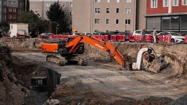
How does GPS machine control speed up earthwork?
GPS machine control speeds up earthwork by guiding the bucket or blade to the design surface in real time with centimeter-level accuracy, which removes most rework, cuts over-digging, and reduces the need for crews to climb in and out checking grade. The operator watches a cab display and stops exactly at design instead of guessing.
Under the hood, GNSS positioning gives the machine its location on the ground while an inertial sensor tracks pitch, roll, and heading so the reading stays stable on rough, moving terrain. Sensors on the boom, stick, and bucket calculate where the teeth sit against the design at every moment. Factory systems from Caterpillar, Komatsu, and John Deere now ship with this built in, and some can take partial control of the hydraulics so the bucket never over-cuts.
The schedule gains show up in a few specific places:
- Less over-excavation, so there is less material to haul back, refill, and compact;
- Fewer grade checkers on the ground, which keeps people out of the machine swing zone and frees up labor;
- More consistent output between senior and mid-level operators, since the cab display narrows the skill gap;
- Fewer remedial passes, because the bucket reaches design grade the first time.
The role of drone surveying
Drone surveying compresses a survey that once took days into a couple of hours, producing accurate maps and cut-and-fill volumes that keep grading decisions from stalling. A short flight turns into a current picture of the entire site the same afternoon.
The outputs are practical, not flashy. An orthomosaic gives a distortion-corrected aerial map, and a 3D point cloud adds elevation so engineers can compare actual ground against design grade and calculate exact material volumes without sending a crew out with a rod. Run a flight before the first shovel and you get a clean baseline for grading and logistics. Run one weekly and you can verify quantities, catch drift early, and keep every trade working from the same up-to-date site model.
Telematics and fleet visibility
Telematics keep timelines on track by showing where every machine is, how hard it is working, and when it needs service, so equipment stays productive and small problems get caught before they turn into downtime. A stalled excavator on a critical path can cost a full day, and telematics exist to stop that.
Geofencing flags machines that leave the site or sit idle. Usage data shows whether the fleet is sized right for the work. Most useful of all, engine and hydraulic data feed predictive maintenance, so a part gets swapped during a planned window instead of failing mid-dig. When that data plugs into the project software a team already uses, equipment status sits right next to the schedule.
Traditional digging vs technology-driven schedules
The clearest way to see the difference is to line up the same tasks under the old method and the connected one.
| Task | Traditional approach | Technology-driven approach |
| Site survey | Crew on site for days, results back later | Drone flight, usable model in hours |
| Setting grade | Stakes, string lines, frequent re-checks | 3D model loaded straight into the machine |
| Earthwork verification | Manual measurement, slow and error prone | Cut-and-fill volumes from aerial data |
| Rework | Common, from over-digging and bad reads | Rare, because the bucket hits design first |
How does this look on a real project?
On a real job the tools stack: a drone maps the site, a 3D model is built from that data, GPS machines grade to the model, and telematics keep the fleet moving, which is how a phase that used to take weeks gets done in days. Each tool covers a weak spot in the old workflow.
Take something as routine as gravel pad installation. The “Site Prep” company approach pairs GPS-guided excavation with a drone flight before and after the dig, so the pad lands at the exact design grade on the first attempt, the gravel quantity matches the takeoff instead of getting over-ordered, and the next trade shows up to a finished, verified surface with no callback. That is the whole point of the technology, fewer surprises and a schedule that actually holds.
A connected earthwork phase usually runs in this order:
- A drone flies the site and produces a current surface map within hours;
- Engineers build a 3D design model and load it into the machines;
- GPS-guided excavators and dozers cut and fill straight to that model;
- A follow-up flight confirms the grade and the material quantities before the next trade arrives.
Is the upgrade worth the cost?
For most contractors, yes. The savings on rework, hauling, idle labor, and missed deadlines usually cover the investment within the first handful of projects, and the gap only widens on tight-margin work where a few lost days eat the whole profit.
The real hurdle is rarely the hardware. It is adoption. The contractors who get the full payback are the ones who train operators to trust the cab guidance and build the digital workflow into how they run every job, not just the showcase ones. Get that part right and smart excavation stops being a line item and starts being the reason the schedule never slips.