Land survey antennas are used to obtain accurate measurements of the location of land features using the Global Positioning System. With the use of GNSS technology, the speed and productivity of professional surveyors have increased dramatically. However, there are many limitations to using GPS for land surveying. In this article, we will discuss some of the challenges that land surveyors face and the advantages that they can gain by adopting GNSS technology.
GPS for land surveying has its limitations
GPS, or Global Positioning System, is a satellite-based navigation system. It provides accurate location information in any weather condition. This technology can be used for several purposes in the surveying industry.
The accuracy of GPS data depends on the quality of the equipment and the skill of the technician. In addition, the signals of the satellite can be affected by a variety of factors, such as obstacles or weather conditions.
Surveyors use GPS to determine the location of two points. They also use the technique to measure distances between them.
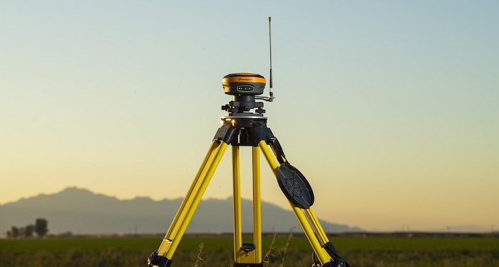
There are three basic methods to collect GPS data: static, kinematic and fast static. Kinematic methods produce the most points in the least amount of time.
Static GPS surveying has been around since the early days of the surveying industry. It is still used today, but has evolved and changed with the times. Typically, the technique involves gathering simultaneous data between stationary receivers over a period of time.
NGS established four orders of control point accuracy for land survey antennas
The National Geodetic Survey (NGS) has been keeping track of the state of the art in geodetic control for nearly a century. This includes more than a million points submitted by professional surveyors. NGS conducts research to help improve spatial data. It is also the home of the NSRS, a system of permanently monumented survey marks.
The NSRS is made up of several User Densification Networks (UDNs) including the aforementioned scalades, as well as Cooperative Base Networks and Federal Base Networks. There are approximately 300,000 horizontal and 600,000 vertical control points in the NSRS fold. A good guess is that the majority of these data sets are derived from GPS based surveying. Interestingly, the state of Colorado is among the states that a GPS based primary horizontal control survey must meet the aforementioned MHAT. Similarly, the use of an existing municipal datum may be limited to approved locales. If that’s the case, the aforementioned MHAT must be the best fit.
GNSS technology has dramatically increased the speed and productivity of professional surveyors
Surveying is the process of determining the position of objects by measuring the angles, distances, and elevations between them. These measurements are used to establish legal boundaries and create topographic maps. There are several methods for surveying.
Triangulation is one method of determining the horizontal position of an object. This technique was introduced prior to the use of electronic distance measurement devices. It was primarily used for establishing benchmarks in remote areas.
Today, the use of electronic distance measurement has allowed surveyors to measure more accurately. This allows them to determine the distance between distant objects and extend control networks. The accuracy of short-range EDMs can be up to one part in 20,000.
For a long time, surveyors used a field receiver to determine the location of a point. Their observations were laborious. Observations were also inaccurate due to the sparse coverage of satellites.
In the early 1970s, the US Air Force launched prototype GPS satellites. These satellites provided position information for Polaris missile submarines.
Harxon’s HX-GS288A mini GNSS survey antenna
HARXON has launched a mini GNSS survey antenna that can receive both GLONASS and GPS frequencies. The HX-GS288A is designed to provide high gain in the L1 and L2 bands. It can be used for a range of applications including land survey, channel survey, seismic monitoring, and marine survey.
This mini GNSS survey antenna features a multi-point feeding design that provides excellent out-of-band rejection and anti-multipath rejection. It has an IP67 waterproof rating and a ruggedized housing. A magnetic mount and pole mount are also included in the package.
The antenna has a MTBF of 30,000 hours and can operate in harsh environments. This choke ring antenna is a 50% smaller version of the popular HX-CGX601A. It is a 185mm diameter, 148mm high, and weighs 2KG. With a sub-millimeter positioning accuracy, it is able to maintain its excellent performance.
Harxon’s HX-GS288A mini GNSS survey antenna is a highly stable device that is unaffected by antenna rotation and satellite elevation. It is designed to be easy to install.