Imagine walking through the giant Himalayas with nothing but a crumpled paper map, a small compass, and the hope you’re heading in the right direction. That’s how trekkers did it not too long ago.
Fast forward to today, you can stand on the same trail, check your exact location on your phone, know tomorrow’s weather, track your heartbeat, and even send a message to your family from the middle of nowhere.
From old-school explorers to modern-day adventurers, technology has completely changed the way we trek. Let’s take a fun journey through time to see how Himalayan adventures went from guessing the path to having the whole trail in your pocket.
The Era Before Technology – Trekking with Paper Maps and Compasses
Before phones and GPS existed, trekkers carried big paper maps and a small compass to find their way. These tools worked well, but they had challenges, especially in the high mountains.
In remote areas, paper maps could get wet in the rain, torn by wind, or sometimes be outdated. If clouds covered the mountains, it was hard to match the map with the real view.
Early explorers of the Annapurna, Langtang Valley Trek, and Everest regions had to be very careful. They depended on their map-reading skills, the stars, and help from local guides. Every trek felt like a real adventure because there was no backup technology.
The Rise of GPS and Digital Mapping
Then came GPS (Global Positioning System), a tool that could tell you exactly where you were on Earth using satellites in space. Handheld GPS devices became popular with trekkers.
Compared to paper maps, GPS was faster and more accurate. It could work even in fog or snow. But you needed batteries and sometimes the signal was weak in deep valleys.
Popular GPS devices among Himalayan trekkers include Garmin eTrex and Garmin GPSMAP series. These devices made navigation much easier, especially for solo adventurers.
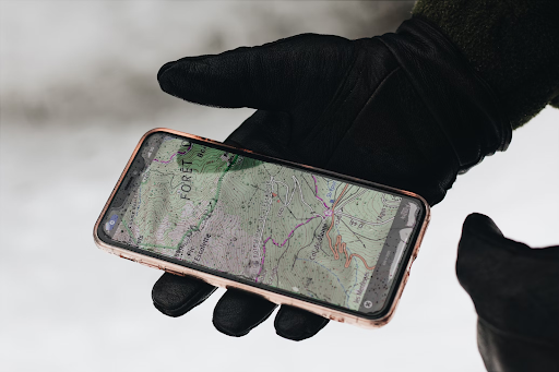
Trekking Apps – Planning and Navigation in Your Pocket
Today, many trekkers don’t carry heavy GPS devices, they use apps on their phones instead.
Apps like Maps.me, Gaia GPS, AllTrails, and the Himalayan MapHouse app allow you to download offline maps before your trek. This means you can still use them even without the internet.
These apps also show real-time weather, elevation profiles, and trail conditions. For example, if you’re trekking the Annapurna Circuit Trek, you can see how steep the next climb is and where the nearest village is located.
Wearable Tech for Safety and Health Monitoring
Today’s trekkers can wear smartwatches that do far more than just tell the time. These devices can:
- Track your GPS location – so you always know exactly where you are, even in fog, snow, or remote valleys.
- Measure altitude – letting you see how high you’ve climbed and helping you adjust your pace.
- Check your heart rate – warning you if your body is under too much stress.
Some advanced models, like Garmin Fenix or Apple Watch Ultra, even show weather alerts and can send your location in case of emergency.
At high altitudes, like Thorong La Pass (5,416 m) on the Annapurna Circuit, the air has much less oxygen. That’s where a pulse oximeter becomes very useful. This small device clips to your finger and measures your oxygen saturation level (SpO₂).
- A healthy reading at sea level is usually 95–100%.
- On high mountain trails, it’s normal for it to drop a bit.
- If it falls too low, say below 80%, it’s a sign your body is struggling, and you should rest, hydrate, or descend.
Why this matters:
Low oxygen levels can lead to altitude sickness, which can cause headaches, dizziness, and nausea. If ignored, it can develop into serious conditions like HAPE (fluid in the lungs) or HACE (swelling in the brain).
By using wearable tech, trekkers can spot problems early and take action before it’s too late. In many cases, these tools have helped trekkers make smart decisions and finish their journey safely.
Staying Connected – Communication Technology in the Himalayas
In remote valleys, phone signals are weak or missing. That’s why trekkers carry satellite messengers and emergency beacons. These devices can send your location to rescue teams, even without mobile networks.
Some trekking groups use walkie-talkies to talk between members on the trail.
There are real-life stories where these tools saved lives, for example, when trekkers got lost in snowstorms or needed medical help far from villages.
Photography and Drones – Capturing the Himalayas from Above
Drones have changed how we see the mountains. They can take amazing aerial photos and videos of peaks, valleys, and villages.
In Nepal, you need a permit to fly drones, especially in national parks. Trekkers must follow ethical rules, like not disturbing wildlife or flying too close to people’s homes.
Used carefully, drones make memories even more beautiful.
Sustainable Trekking Through Modern Technology
Technology also helps trekkers protect the environment. Solar chargers power devices without needing extra batteries. Portable water purifiers allow trekkers to drink clean water without buying plastic bottles.
Many trails now have refill stations so trekkers can fill reusable bottles instead of throwing away plastic.
Apps can also show the location of these eco-friendly services, helping travelers make better choices.
The Future of Trekking Technology – VR, AR, and AI
Imagine exploring the Annapurna Circuit trek in virtual reality before you even start. VR and AR (Augmented Reality) can help trekkers plan better by showing 3D maps and routes.
In the future, AI trekking assistants might suggest the best path based on your fitness, the weather, and your preferences.
But we must remember: too much dependence on technology can be risky if devices fail or batteries die.
Conclusion
Technology has made trekking safer, easier, and more fun. But traditional skills, like reading a map, using a compass, and understanding the weather, are still important.
The best Himalayan adventures come when you mix the wisdom of the old ways with the power of new tools.
So, next time you go trekking, embrace technology, but also keep the true spirit of adventure alive!