Drones are playing a growing vital role in modern society, with applications spanning aerial photography, agricultural spraying, logistics delivery, and infrastructure inspection. However, the operational scenarios for drones are complex and ever-changing, presenting significant challenges from various environmental factors. These conditions not only directly affect flight stability but also severely test the reliability of the drone detection systems, ultimately impacting overall mission success rates.
Key Functions of UAV Detection Systems
To understand how the environment impacts these systems, it is essential to first define their core operational functions, which form the foundation of UAV safety and mission accuracy:
- Precision Altitude Holding: Maintain a steady flight level even in turbulent or uneven air conditions.
- Obstacle Avoidance: Detect and respond to potential hazards in time to prevent collisions.
- Precision Landing: Execute controlled descents on uneven or moving surfaces with minimal deviation.
Major Environmental Challenges of Drone Detection Systems
A variety of external factors can degrade the accuracy and reliability of drone detection systems. From lighting and weather to terrain and signal distortion, each presents a unique test for onboard sensors in real-world operations.
Lighting Condition Interference
Lighting is a critical variable for drone perception, with distinct challenges across different conditions:
- Strong Light (above 100 KLux): Intense sunlight can cause overexposure and loss of saturation in visible light images, rendering vision algorithms ineffective. Simultaneously, it drastically increases background noise in conventional LiDAR, causing a sharp decline in signal-to-noise ratio and making it difficult to distinguish valid return signals.
- Low Light or Night: In dark or nighttime environments, visible-light cameras lose effectiveness entirely.
- Rapid Light Changes: When drones move through mixed lighting, such as forested areas or near structures casting moving shadows, sudden brightness variations can disrupt Visual-Inertial Odometry (VIO) calculations, leading to temporary positioning drift or instability.
Meteorological Factors
- Extreme Temperatures: Both high and low temperatures affect electronic components inside drone detection systems. Excessive heat can cause parameter drift or thermal shutdowns, while extreme cold risks startup delays or sensor malfunction.
- Wind Influence: Strong wind does not affect sensors directly but causes airframe vibration, which leads to blurred imagery and higher noise levels. This increases the difficulty of data denoising and image stabilization during post-processing or real-time analysis.
Complex Terrain and Signal Challenges
Certain environments can distort signals or block positioning data entirely. Here is why:
- Multipath Interference: In areas surrounded by reflective surfaces such as metal structures or tall buildings, sensor signals like LiDAR beams or millimeter waves may bounce multiple times before returning. This creates false reflections, or “ghost targets,” which confuse obstacle detection systems.
- GPS Signal Blockage: In dense forests, urban high-rises, or tunnels, GPS and GNSS signals can become weak or completely obstructed, leaving drones without reliable positioning data.
Consequences of Drone Detection System Failure
A malfunction or misreading in a drone detection system can disrupt an entire mission. Even minor sensor errors can multiply under complex flight conditions, bringing data loss, operational downtime, or safety incidents.
Deterioration of Data Quality
When a perception system begins to lose signal integrity, the collected data becomes unstable. “Jump points” and excessive noise distort positional accuracy, causing irregular altitude maintenance or drifting in flight path control.
Mission Interruption
Unstable perception often forces the UAV to halt in midair, initiate a return-to-home sequence, or abort the mission entirely. Each interruption results in lost operational time, wasted energy, and reduced overall efficiency. In industrial or commercial applications, these failures translate directly into financial losses and project delays.
Safety Risks
The failure of a drone detection system creates immediate and serious hazards. An inability to recognize real-world obstacles, such as power lines, trees, or structures, puts the UAV at high risk of collision. Crashes can destroy costly equipment and payloads, and more critically, pose a significant threat to property and personal safety on the ground.
How Benewake Optimizes Environmental Adaptation of Drone LiDAR
Benewake drone LiDAR sensors are designed to operate reliably under harsh and unpredictable outdoor conditions. The key adaptations include:
Optical System and Anti-Ambient Light Algorithm Optimization
Benewake equips its LiDAR sensors with a refined optical structure and dedicated anti-ambient light algorithms, which work in tandem to suppress interference from strong sunlight and reflective surfaces.
By actively filtering high-intensity ambient light, these UAV LiDARs maintain a stable signal-to-noise ratio. This enables them to distinguish true targets even in environments exceeding 100 kLux, ensuring steady performance in both bright daylight and low-visibility conditions.
Enhanced Signal Processing Technology
To preserve data accuracy under challenging conditions, Benewake integrates adaptive signal processing technology that continuously analyzes and adjusts signal amplification in real time.
This intelligent adjustment enhances target recognition, reduces false returns, and stabilizes detection in dust, rain, or fog. As a result, the LiDAR UAV detection maintains clear and consistent readings even when atmospheric noise levels are high.
Environmentally Adaptive Structure
Beyond optical and algorithmic improvements, Benewake focuses on the mechanical resilience of drone LiDAR. The sensor is built using wide-temperature-range electronics and a high IP-rated enclosure that protects against dust, moisture, and debris.
Benewake TFA300 Series
The core design philosophies described above have been systematically integrated and realized in Benewake’s product portfolio. Taking the Benewake TFA300 series as an example, it is precisely engineered to meet the harsh environmental challenges outlined earlier, translating theoretical optimizations into reliable real-world performance and ensuring that drones maintain “clear and stable” perception even under extreme operating conditions.
-
Excellent Environment Adaptation
The TFA300 series has been comprehensively optimized for complex UAV applications, capable of operating under extreme temperatures, 100 kLux ambient lighting, rain, fog, and sand. It effectively addresses the common false detection issues found in traditional LiDAR.
To date, the TFA300 series has enabled global delivery drone customers to achieve over 400,000 safe and accident-free parcel deliveries.
-
Additional Key Features
Beyond its exceptional environmental resilience, the drone detector boasts several key features essential for high-end drone operations:
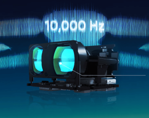
- Ultra-High-Frequency Sensing: Operating at up to 10,000 Hz, it provides rapid distance updates that enable real-time obstacle detection even at near Mach 1 flight speeds. This high refresh rate ensures accurate spatial awareness for fast and dynamic UAV missions.
- Compact and Lightweight Structure: The TFA300-L weighs only 10.5 g, while the IP67-rated TFA300 model adds enhanced protection at 34.5 g. The compact size permits direct integration into EO/IR gimbals and UAV payloads, optimizing the balance between size, weight, power, and cost.
- Easy Integration: Crafted with JST GH connectors and a CAN interface, the TFA300 series can connect seamlessly with next-generation flight control platforms. It supports the DroneCAN protocol, enabling plug-and-play compatibility and reducing development time for UAV manufacturers.
Wrapping-up
The operational reliability and safety of UAVs remain inextricably linked to the environmental resilience of their drone detection systems. Benewake’s LiDAR solutions, exemplified by the TFA300 series, demonstrate how targeted innovations in optical design, signal processing, and mechanical durability can effectively mitigate environmental challenges, allowing drones to operate with confidence, accuracy, and safety.
Ready to build this resilience into your fleet? Explore Benewake LiDAR sensors now!