
Artificial intelligence is advancing the ability of computers to analyze information, recognize patterns and support increasingly complex decisions. But many of the problems organizations need to solve are fundamentally geographic. Infrastructure has a location. Transportation networks connect places. Environmental risks affect specific regions. Assets operate within physical environments and relationships.
For AI systems to make sense of these challenges, location must be more than a label attached to a record. It must become part of how systems understand the world.
That is one of the important ideas behind the evolution of geographic information systems (GIS). Once primarily associated with mapping and land inventories, GIS has developed into a foundation for spatial analysis, infrastructure management, digital twins and location-aware intelligence.
A white paper published by Jon Peddie Research, “GIS grew from maps to intelligence”, traces the technology's development and explores why its next phase may be closely connected to AI and the growing need for systems that can reason about the physical world.
GIS began by making geography usable as data
The foundations of computerized GIS date back to practical land-management challenges. In Canada, the need to classify and analyze rural land across agriculture, forestry, wildlife, recreation, soils and water resources led to the development of the Canada Geographic Information System (CGIS), which began in 1963.
Roger Tomlinson's approach helped establish a model in which geographic boundaries could be connected to descriptive attributes and analyzed across multiple layers. A map could now represent more than the outline of a property or region. It could contain information about soil quality, land capability, crop potential, forestry value and conservation status.
This distinction remains important. GIS is not simply a way to display where something is located. It provides a structure for understanding what exists at a location, how different features relate to one another and what those relationships may mean.
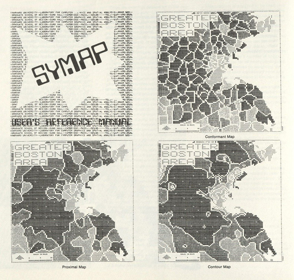
The early development of GIS involved several complementary technologies. Harvard University's SYMAP software demonstrated that computers could generate thematic maps from tabular information. CAD systems supplied precision graphics and vector editing. Digitizing equipment from companies such as Summagraphics helped convert paper maps and engineering drawings into digital coordinates.
Commercial developers then connected these capabilities to practical workflows. Intergraph brought engineering graphics into mapping applications, while Synercom helped advance Automated Mapping and Facilities Management (AM/FM) for utilities and infrastructure. ESRI's ARC/INFO combined geographic processing with relational database capabilities, helping establish GIS as a platform for spatial data management and analysis.
The technology matured through collaboration, with each contribution addressing a different requirement.
Why location is more than metadata
Modern organizations work with enormous amounts of information from different systems. Infrastructure operators may have engineering drawings, asset records, maintenance histories, sensor readings and operational data. Cities may work with property information, transportation networks, zoning records, environmental conditions and public services.
These datasets become more useful when they can be connected through geography.
GIS provides a spatial framework for organizing information according to location, relationships and geographic context. It can help identify which assets are near one another, which areas are affected by a particular condition, how networks connect and where a change may have consequences.
This is particularly important for infrastructure and utility management. A map connected to an asset database can provide a geographic view of pipes, power lines, service areas and maintenance records. Instead of looking at an isolated drawing or spreadsheet, users can understand an asset in relation to the surrounding network and the information associated with it.
The white paper's history of AM/FM systems illustrates how this operational approach developed. Utilities needed more than digital maps. They needed asset identifiers, maintenance information, circuit details, pipe sizes, service areas and work histories connected to geographic features. That requirement helped push GIS beyond cartography and toward enterprise information management.
Digital twins need a geographic foundation
Digital twins extend this idea by connecting digital representations of physical assets, facilities or environments with information about their real-world operation.
A static three-dimensional model can show what an object or facility looks like. A more capable digital twin can incorporate changing information and provide a context for understanding how the physical asset is performing.
GIS can serve as the geographic framework that brings these different sources together. Sensor telemetry, building information modeling (BIM) files and business records can be connected through location, creating a more unified view of an asset or environment.
The result is a digital representation that can move beyond visualization. When geographic information is connected with operational data, users can examine relationships between assets, understand conditions across a site or network and make decisions with a clearer view of the surrounding environment.
This is especially relevant in cities, transportation, construction, utilities and other fields where assets are interconnected and conditions vary by location.
The next step: AI that understands spatial relationships
The growing connection between GIS and AI raises an important question: What happens when AI systems can reason about geography rather than simply receive location as another data field?
Maps, satellite imagery, CAD models, sensors and asset databases can provide AI systems with information about the physical environment. But making that information useful requires more than identifying coordinates. Systems also need to understand topology, proximity, terrain, networks, time and constraints.
For example, identifying the closest facility is not necessarily the same as determining the most practical facility to reach. A useful decision may depend on road networks, access restrictions, terrain, travel conditions and the relationship between different assets.
Similarly, infrastructure analysis may require understanding how one component connects to another, which areas could be affected by a disruption and how conditions change over time.
GIS has spent decades developing the data structures and analytical methods needed to represent these relationships. That foundation could become increasingly valuable as AI applications move into logistics, infrastructure inspection, city management, environmental analysis and risk simulation.
The opportunity is not simply to put AI on top of a map. It is to give AI systems a structured understanding of the physical world in which their decisions will be applied.
A history that points toward the future

The development of GIS offers a useful perspective on how complex technology platforms evolve. Government land inventories established early requirements. University research demonstrated computer mapping. CAD systems contributed precision graphics. Digitizers made data capture possible. Commercial software connected geography with databases and operational workflows. Professional organizations helped establish standards and build a community of users.
Each contribution addressed a different limitation, and together they created the foundation for today's location intelligence systems.
That history also helps explain why the future of GIS is not limited to producing better maps. As organizations connect more data sources and adopt digital twins, cloud platforms and AI, geographic context can become a central part of how information is interpreted and decisions are made.
The next generation of location-aware systems will need to understand not only where things are, but how they connect, interact and change within the physical world.
For a detailed look at the technologies, companies and developments that shaped this field, read “GIS grew from maps to intelligence,” the white paper published by Jon Peddie Research.